Start date 16 August 2019
End date 15 August 2021
Funded under H2020-EU.1.3.2, Grant agreement ID: 835997
Overall budget € 174 806,40
Introduction:
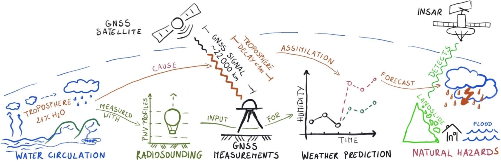
The project „Real-Time GNSS for European Troposphere Delay Model (ReS4ToM)” aims at developing “a novel real-time model of the troposphere by using Global Navigation Satellite Systems (GNSS) derived troposphere delays, gradient information and precipitable water vapor (PWV) content”. Remote sensing of the troposphere with GNSS, so-called GNSS meteorology, provides observations of spatial and temporal resolution higher than any other technique and operates under all weather conditions. Therefore, hundreds of permanent GNSS stations in Europe are used by several analysis centers to operationally sense the troposphere under the E-GVAP project for monitoring water vapor by the help of GNSS. Troposphere products estimated from GNSS observations from the two oldest systems, i.e., GPS and GLONASS, are delivered with a latency reaching one hour. A real-time service, rather than a delayed provision of accurate troposphere products, from quad-constellation GNSS remains a goal. In addition to zenith total delay (ZTD), advanced troposphere products like horizontal gradients and slant delays gain more attention over recent years.
The main product of GNSS meteorology, the ZTD, can be assimilated into numerical weather prediction (NWP) models in order to improve weather forecasting. This is particularly important for severe weather events, e.g., heavy rainfalls and hailstorms, for which reliable prediction and forecast still remains a challenge. The dynamics of troposphere gradients can reveal additional information on troposphere asymmetry, and troposphere slant delays can be further used to reconstruct the three-dimensional distribution of water vapor. With low-cost GNSS receivers the tracking network can be densified and thus the spatial density of sensing the troposphere can be increased from tens of kilometers to single kilometers. This allows to observe local dynamics of water vapor and increases the accuracy of forecasts for urban areas.
Objectives:
- to combine in a consistent and operational way multiple novel aspects of GNSS data processing;
- to compute and validate real-time GNSS-based troposphere delay model for user and to provide it online making use of open standards;
- to check how the troposphere products support geodetic techniques and improve weather forecasting;
- to investigate the potential and limitations of the low-cost GNSS receivers for GNSS meteorology.
Major outcomes:
- Definition of the superior strategy for the real-time estimation of tropospheric products (zenith total delay, horizontal gradients) from GNSS observations.
- Identification of benefits of using combined GPS+Galileo observations on troposphere products, i.e. higher accuracy, higher availability and suppression of artificial low-frequency signals in the ZTD.
- Development of the service, which estimates troposphere products in real-time from any GNSS station providing observation via an RTCM stream.
- Confirmation of the high accuracy of real-time ZTD products; they fulfill accuracy requirement for the assimilation into a Numerical Weather Model.
- Identification of clear patterns in horizontal gradients during the presence of a severe weather event.
- Demonstration of the potential of low-cost GNSS receivers to provide accurate and reliable real-time information on water vapor content in the troposphere.
Publications:
- Hadas T., Hobiger T.: Benefits of Using Galileo for Real-Time GNSS Meteorology. IEEE Geoscience and Remote Sensing Letters, Vol. No. , Piscataway, NJ, USA 2020, pp. 1-5. DOI: 10.1109/LGRS.2020.3007138
- Hadas T., Hobiger T., Hodryniec P.: Considering different recent advancements in GNSS on real-time zenith troposphere estimates. GPS Solutions, Vol. 24 No. 99, Berlin - Heidelberg 2020, pp. 1-14. DOI: 10.1007/s10291-020-01014-w
- Wielgocka N., Hadas T., Kaczmarek A., Marut G.: Feasibility of Using Low-Cost Dual-Frequency GNSS Receivers for Land Surveying. Sensors, 2021, vol. 21, no. 6, pp.1-14, Article number:1956. DOI:10.3390/s21061956
- Hadas T., Bender M., Marut G., Hobiger T.: Real-time GNSS Meteorology in Europe – Hurricane Lorenzo Case Study. IEEE (accepted, waits for the publication), 2021
Conference materials:
- Hadas T., Kazmierski K., Sośnica K., Performance of Galileo-only Positioning Using the Current Galileo Constellation. 4-6.09.2019
- Hadas T., Hobiger T.: Real Time GNSS Meteorology: State of the Art and Challenges. European Meteorological Society Annual Meeting 2019, Copenhagen, Denmark, 11.09.2019
- Hadas T., Hobiger T.: Real Time GNSS Meteorology: State of the Art, Challenges and Perspectives. Second Summer School of DAAD Thematic Network, Stuttgart, 11-16.09.2019
- Bryłka P., Tondaś D., Hadas T., Kapłon J.: Low-Cost Receivers for GNSS Meteorology. GNSS Meteorology Workshop 2019, Wroclaw, Poland. 19-20.09.2019
- Hadas T., Hobiger T.: Contribution of Galileo to real-time GNSS meteorology. International Workshop on Improving GNSS and SAR Tropospheric Products for Meteorology, Luxembourg. 24-26.02.2020
- Hadas T., Marut G., Kapłon J., Rohm W.: Real-Time ZTD from a Local Network of Low-cost Dual-frequency GNSS Receivers. European Geophysical Union General Assembly 2021, Vienna, Austria (online), 29.04.2021
- Hadas T., Wielgocka N., Kaczmarek A., Marut G.: Precise Positioning using Low-Cost Dual-frequency GNSS Receivers. Scientific Assembly of the International Association of Geodesy 2021, Beijing, China (online). 28.06-2.07.2021
- Hadas T., Marut G., Kaplon J., Rohm W.: Determination of Water Vapor Content Using Low-cost Dual-Frequency GNSS Receivers. Scientific Assembly of the International Association of Geodesy 2021, Beijing, China (online). 28.06-2.07.2021
- Hadas T., Bender M., Marut G., Hobiger T.: Real-time GNSS Meteorology in Europe – Hurricane Lorenzo Case Study. International Geoscience and Remote Sensing Symposium 2021. Brussels, Belgium (online). 12-16.07.2021
Online materials:
- https://www.youtube.com/playlist?list=PL1gjsBn7WurAyGAtCO1oxF4vxIo3rkQTn
- https://www.youtube.com/playlist?list=PL1gjsBn7WurAVhtcW0BZK2AR_f2OMCfMP
- https://156.17.181.133/ZTDVis/
Datasets:
- Real-time ZTD and gradients from 20 IGS stations; year 2019, https://zenodo.org/record/5190072
- Real-time ZTD and gradients from 161 EPN stations; year 2020, https://zenodo.org/record/5190716
- Real-time GNSS troposphere products: ZTD and gradients - hurricane Lorenzo case study, https://zenodo.org/record/5196195
- GNSS troposphere products from a network of low-cost GNSS receivers, Wroclaw, Poland, March-April 2021, https://zenodo.org/record/5196311
Final report:
- PDF link comming later